
 UAE
UAEKedarnath Yatra Route Map: Roads, Trek, and Travel Tips Explained
📑 Table of Contents
The Kedarnath yatra route map is the most important planning tool for anyone preparing for this sacred Himalayan pilgrimage. Every year, thousands of devotees travel to Kedarnath Temple, one of the twelve Jyotirlingas of Lord Shiva, located at an altitude of 3,583 meters in the majestic Garhwal Himalayas. The journey is not just spiritual; it also involves careful logistical planning due to the mountainous terrain, high altitude, and limited connectivity.
Understanding the Kedarnath route map helps pilgrims visualize the complete journey from major Indian cities to the road head at Gaurikund, and then the 16–18 km trek to the temple. Whether you are traveling by road, train, air, or helicopter, each route follows a structured path through Uttarakhand’s hill towns and river valleys. The terrain, weather conditions, and seasonal accessibility also influence how you plan your visit, where a well-planned kedarnath yatra package can be especially helpful.
This detailed guide explains how to reach Kedarnath, travel options, the new trek route after 2013, facilities along the path, route tables, and essential travel tips for a smooth Kedarnath pilgrimage.
Introduction to Kedarnath Yatra & Route Difficulty
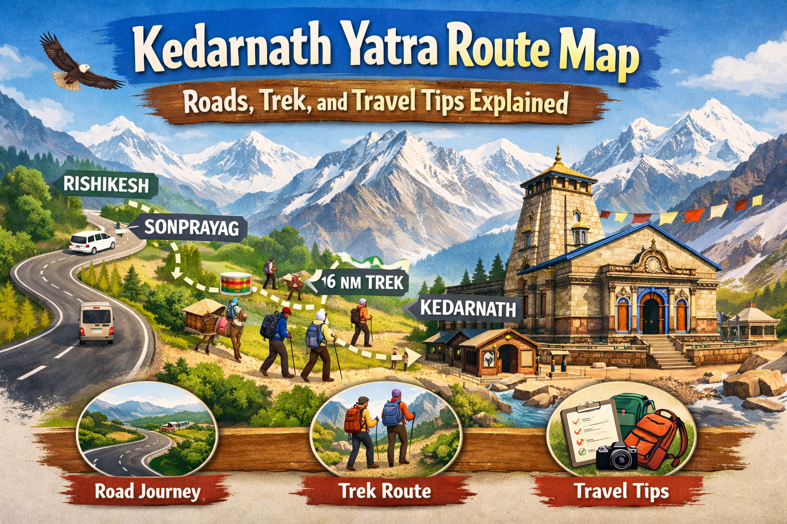
The Kedarnath Yatra is one of the most revered pilgrimages in India and forms an integral part of the Char Dham circuit of Uttarakhand. Unlike many other temple visits, reaching Kedarnath requires both road travel and a mountain trek. The kedarnath yatra route map includes highways from Haridwar and Rishikesh, winding hill roads through Rudraprayag district, and finally an uphill trekking path from Gaurikund.
Route difficulty depends on two main factors: mountain road travel and high-altitude trekking. The roads leading up to Sonprayag and Gaurikund are narrow and prone to landslides during monsoon. After reaching Gaurikund, pilgrims must either trek 16–18 km or opt for pony, palki, or helicopter services. The climb is steady and continuous, which can be physically demanding, especially for those not accustomed to walking long distances at high altitude.
However, the route is well-managed during the yatra season. Police checkpoints, medical camps, and rest shelters are stationed at intervals. The overall difficulty level is moderate, but preparation and awareness make the journey smoother.
Travel Options to Kedarnath
Understanding how to reach Kedarnath is essential before planning your itinerary. The kedarnath yatra route map includes multiple transportation modes — road, train, air, and helicopter — each suitable for different traveler preferences.
By Road to Kedarnath
Traveling by road is the most common option. Pilgrims usually reach Haridwar or Rishikesh first, then proceed toward Rudraprayag, Guptkashi, Sonprayag, and finally Gaurikund. The mountain roads are scenic but involve sharp turns and elevation gain.
Major Road Route:
Haridwar → Rishikesh → Devprayag → Srinagar → Rudraprayag → Guptkashi → Sonprayag → Gaurikund
From Sonprayag onward, private vehicles are restricted. Shared local taxis operate between Sonprayag and Gaurikund. The road journey can take 8–10 hours from Haridwar depending on traffic and weather.
By Train to Kedarnath
There is no direct railway station at Kedarnath. The nearest railway stations are:
-
Haridwar
-
Rishikesh
-
Dehradun
From these stations, travelers must continue by road to Gaurikund. Trains connect these cities to Delhi, Mumbai, Kolkata, and other major Indian metros. The train + road combination is budget-friendly and widely used by pilgrims.
By Air to Kedarnath
The nearest airport is Jolly Grant Airport in Dehradun. It connects to Delhi and other major cities. From the airport, travelers proceed by road toward Guptkashi and Gaurikund. This option reduces travel time significantly for long-distance travelers.
By Helicopter to Kedarnath
Helicopter services operate from Phata, Guptkashi, and Sersi. This is the fastest way to reach Kedarnath, especially for elderly pilgrims. Flights operate subject to weather conditions and require advance booking during peak season. Helicopter travel eliminates the need for trekking, making it ideal for those with physical limitations.
New Kedarnath Trek Route After 2013 Floods
The 2013 disaster significantly impacted the old trekking route. After reconstruction, a new Kedarnath trek route was developed to ensure safety and better infrastructure. The revised route is longer but wider and more secure.
The current trek path follows:
Gaurikund → Jungle Chatti → Bheembali → Linchauli → Kedarnath
The new path avoids vulnerable riverbanks and landslide-prone zones. It includes reinforced pathways, steel bridges, and marked resting areas. Authorities have improved slope stabilization and drainage systems to prevent erosion.
The trek is approximately 16–18 km one way and typically takes 6–9 hours depending on fitness level. Although uphill throughout, the improved infrastructure has made it safer compared to the earlier route.
Facilities Along the Trek
Trek facilities to Kedarnath have improved significantly in recent years. The government and local administration provide multiple support services along the route to ensure pilgrim safety.
Medical Facilities
-
First-aid camps at major checkpoints
-
Oxygen support at higher altitude points
-
Emergency evacuation arrangements
-
Health check counters during peak season
Food & Rest Facilities
-
Tea stalls and food counters
-
Drinking water points
-
Rest shelters
-
Temporary accommodation near the temple
Transportation Assistance
-
Pony and mule services
-
Palki (doli) carriers
-
Helicopter services
-
Security personnel throughout the trek
These facilities reduce risks and make the Kedarnath pilgrimage more accessible to people of different age groups.
Route Mapping & Tables
A clear Kedarnath route map helps pilgrims estimate travel distance and time. Below are structured route tables for better understanding.
Haridwar to Kedarnath Route Map
Total Distance to Kedarnath
-
From Haridwar to Gaurikund by road: Approx. 220–230 km
-
From Gaurikund to Kedarnath by trek: 16–18 km
Total travel time usually spans 2 days including rest.
Travel Tips for Kedarnath Pilgrimage
Planning carefully ensures a safe and comfortable journey. The following travel tips for Kedarnath pilgrimage are essential:
-
Start early to avoid traffic congestion.
-
Avoid traveling during heavy monsoon months.
-
Carry warm clothing even in summer.
-
Keep cash as ATMs are limited in remote areas.
-
Register for the yatra in advance through official portals.
-
Stay hydrated but avoid overexertion during the trek.
-
Check weather updates before departure.
Proper Kedarnath yatra route map planning combined with these tips significantly reduces travel stress.
Distances from Major Indian Cities
Below is an approximate overview of distance to Kedarnath (via Haridwar road route):
Travelers from distant cities typically combine flight or train to Dehradun/Haridwar and then continue by road.
Final Thoughts
The kedarnath yatra route map is more than just a geographical layout; it is a structured pathway that connects plains, river confluences, hill towns, and finally the sacred Himalayan shrine. Understanding how to reach Kedarnath by road, train, air, or helicopter helps pilgrims choose the best route based on time, budget, and physical ability.
The new Kedarnath trek route ensures greater safety compared to older paths. As explained in this complete guide for kedarnath yatra, facilities along the trek provide medical, food, and transportation support. With careful planning, realistic time estimation, and adherence to travel tips, the Kedarnath pilgrimage becomes a spiritually fulfilling and logistically smooth journey.
Whether you travel independently or book a tour package, using a detailed Kedarnath route map ensures that your journey to Kedarnath Temple is well-organized, safe, and memorable.
Frequently Asked Questions for Kedarnath Yatra Route Map
1. What is the Kedarnath Yatra route map and travel route?
The typical Kedarnath Yatra route starts from Haridwar or Rishikesh and continues through Devprayag, Rudraprayag, Guptkashi, Sonprayag, and Gaurikund. From Gaurikund, pilgrims complete the trek to Kedarnath Temple.
2. How to reach Kedarnath Temple step-by-step from Haridwar or Rishikesh?
First, travel from Haridwar or Rishikesh to Guptkashi or Sonprayag by road. Then take local transport to Gaurikund. From Gaurikund, start the trek to Kedarnath or use pony, palki, or helicopter services.
3. What is the new Kedarnath trek route after the 2013 floods?
After the 2013 disaster, a safer trekking route was developed from Gaurikund through Jungle Chatti, Bheembali, and Linchauli before reaching Kedarnath Temple.
4. What are the travel options to reach Kedarnath Dham?
Travelers can reach Kedarnath by road until Sonprayag or Gaurikund, followed by trekking. Other options include pony rides, palki services, and helicopter services from nearby helipads.
5. How long is the Kedarnath trek route and total distance?
The trekking distance from Gaurikund to Kedarnath is about 16 to 18 kilometers. Most pilgrims take around 6 to 10 hours, depending on walking speed and weather conditions.
6. What facilities are available along the Kedarnath trek route?
Facilities include rest points, food stalls, medical camps, drinking water points, and shelters. Pony and palki services are also available along the route.
7. What is the distance to Kedarnath from Delhi and other major cities?
The road distance from Delhi to Gaurikund is about 450 kilometers. From Gaurikund, pilgrims must complete the trek to reach Kedarnath Temple.
8. Can we reach Kedarnath by car or road directly?
No, vehicles can travel only up to Sonprayag or Gaurikund. The final stretch to Kedarnath must be completed by trekking or by helicopter.
9. Which route is best for the Kedarnath Yatra for first-time travelers?
The most common and convenient route is Haridwar or Rishikesh to Guptkashi to Sonprayag to Gaurikund, followed by the trek to Kedarnath.
10. What travel tips should I follow for the Kedarnath pilgrimage route?
Start the trek early in the morning, carry warm clothing and rain protection, stay hydrated, walk slowly at high altitude, and keep extra time in your schedule for weather changes.
Kinghills Travel
Travel expert specializing in spiritual journeys across India, with a strong focus on Do Dham and Char Dham Yatra. Passionate about helping travelers experience divine destinations with proper guidance, comfort, and authentic insights. Provides well-researched, practical information to make every pilgrimage smooth and meaningful.
Areas of Expertise:
Credentials:
Years of experience in pilgrimage planning, route guidance, and temple-based travel content.


