
 UAE
UAEChar Dham Yatra Route Map: Complete Distance & Travel Breakdown
📑 Table of Contents
To plan a successful Char Dham Yatra in Uttarakhand, it is important to know about the Char Dham Yatra route map in detail. The Char Dham Yatra is a spiritual route that connects four holy shrines in the Himalayas: the Yamunotri Temple, the Gangotri Temple, the Kedarnath Temple, and the Badrinath Temple, which together make up the Chota Char Dham of Uttarakhand.
Each year, lakhs of devotees embark on this high-altitude journey, covering a distance of 1,500–1,600 kilometers, often opting for a well-planned char dham yatra package to ensure a smooth experience. However, the Char Dham Yatra route map is not just a spiritual path that a devotee follows; it is also a journey that requires proper planning, along with a clear understanding of the terrain, road conditions, and changing weather patterns
This comprehensive guide will help you understand the terrain and travel logistics of the Char Dham Yatra route map in detail.
What is the Char Dham Circuit?
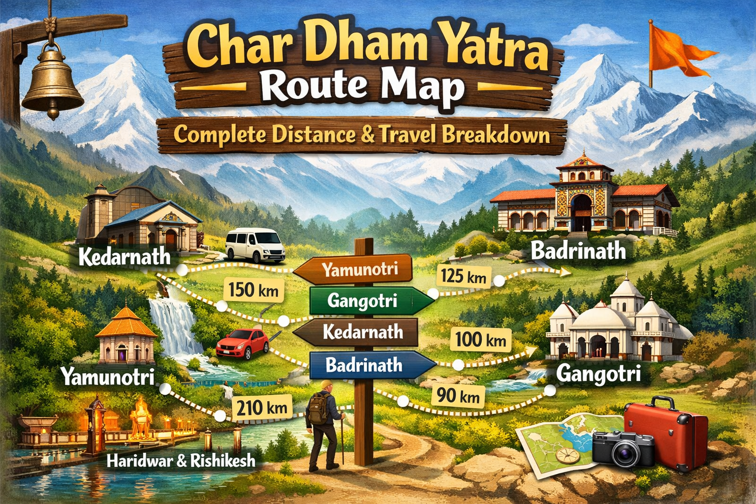
The Char Dham circuit is the traditional clockwise journey undertaken by devotees in Uttarakhand. The journey typically begins from Haridwar or Rishikesh and then moves in the following order: Yamunotri, Gangotri, Kedarnath, and finally Badrinath.
The circuit passes through the Garhwal Himalayas and includes valleys, points where the holy rivers meet, pine forests, and mountain ranges covered with snow. The char dham yatra also varies in altitude from 3,000 meters to above 3,500 meters. This makes the circuit both spiritually and physically taxing.
The Char Dham circuit typically takes 10-12 days to complete by road and includes treks to Yamunotri and Kedarnath.
Important Highlights of the Char Dham Circuit:
-
Starts from Haridwar or Rishikesh
-
Follows a clockwise religious sequence
-
Covers approximately 1,500–1,600 km by road
-
Includes 5 km trek to Yamunotri
-
Includes 17 km trek to Kedarnath
-
Considered one of the most sacred pilgrimages in India
Char Dham Yatra Route Map with Distance From Haridwar
It is important to understand the char dham yatra route map with distance from Haridwar in order to plan the journey properly. The journey is segmented into various parts, with some fixed base points for each of the temples. The devotees need to plan for the long drives in the mountains, the roads, the fueling points, and the trekking routes.
Here is the Char Dham Yatra by Road Route Map. With Distance that is normally followed:
Total road distance: Approximately 1,500 km (excluding trekking).
This detailed char dham map with distance helps pilgrims estimate travel time, fuel, and arrange overnight stays.
How risky is the Char Dham Yatra?
The Char Dham Yatra is a journey through the high-altitude Himalayan regions, which in itself poses some natural risks. These risks are associated with high-altitude routes, landslides, and extreme weather conditions.
But the development projects undertaken by the government, such as the expansion of the Char Dham Highway, have improved the situation to a great extent. The government also sets up disaster relief teams and medical camps during the yatra period.
The major risk factors are:
-
Landslides during the monsoon season
-
High-altitude sickness above 3,000 meters
-
Sharp hairpin bends on mountain roads
-
Traffic congestion during peak months (May–June)
-
Sudden temperature drops in higher regions
All these risks can be overcome with proper planning and awareness.
Char Dham Yatra Road Condition
The road conditions along the Char Dham route vary depending on the region and the time of year. The journey from Haridwar to Barkot is relatively smooth, but once you enter the Himalayan ranges, the roads become narrower, winding, and more challenging.
There are also road widening projects in progress. This might cause some diversions. Some parts of the route near Guptkashi and Sonprayag have steep climbs and turns, which demand expert driving.
General Road Condition Overview:
-
Haridwar to Barkot: Mostly smooth highway
-
Barkot to Uttarkashi: Moderate mountain road
-
Uttarkashi to Gangotri: Narrow but motorable
-
Guptkashi to Kedarnath base: Steep and winding
-
Joshimath to Badrinath: High-altitude but stable
Avoid night driving in mountainous areas for better safety.
Weather Conditions at Char Dham Yatra
The weather conditions affect the Char Dham Yatra route map journey. The temperatures vary greatly due to the high altitude. Even in the summer season, the nights can be very cold at Kedarnath and Badrinath.
The monsoon season (July-August) is prone to landslides and road closures. The post-monsoon season (September-October) is characterized by clear skies and favorable conditions.
Seasonal Weather Breakdown:
-
May–June: Pleasant (5°C to 20°C), peak season
-
July–August: Heavy rainfall, landslides possible
-
September–October: Clear skies, ideal travel
-
November–April: Heavy snowfall, temples closed
Carrying woolens and rain protection is essential in all seasons.
Is Char Dham Yatra Safe?
Yes, the pilgrimage is said to be safe if done during the official char dham yatra season and after proper registration. The Uttarakhand government has made biometric registration compulsory, and medical facilities are also available on the route.
Security forces, emergency services, and health camps are available on the entire route. It is advised that pilgrims take note of the official warnings and weather updates.
Safety Recommendations:
-
Complete government registration
-
Travel during recommended months
-
Stay updated on weather forecasts
-
Consult a doctor before travel
-
Avoid overexertion during treks
Senior citizens and those with heart or respiratory issues should seek medical clearance before traveling.
Can We Do the Char Dham Yatra by Our Own Car?
Although self-driving offers flexibility and autonomy, it also demands mountain driving confidence and car readiness.
The terrain is characterized by steep ascents, sharp corners, and long driving distances. Petrol stations become scarce in higher altitudes; thus, appropriate planning is required.
If Traveling by Your Own Car:
-
Prefer an SUV or a high ground-clearance vehicle
-
Ensure brakes and engine are in top condition
-
Carry a spare tire and an emergency toolkit
-
Keep the fuel tank sufficiently filled
-
Avoid driving at night in the hills
-
Check weather updates before departure
For first-time visitors, hiring an experienced mountain driver is often recommended.
Helpful Tips for Safe Char Dham Yatra
Preparation is the key to a smooth pilgrimage along the 4 Dham Yatra Route Map. Since the journey covers several high-altitude areas, it is necessary to be physically prepared and pack accordingly.
It is necessary to plan each day of the journey carefully and start early to avoid traffic congestion. Acclimatization breaks should also be taken when necessary. The Himalayan ecosystem should be respected by not littering and following eco-guidelines.
Important Travel Tips:
-
Start early each morning
-
Stay hydrated and eat light meals
-
Carry woolens, rain gear, and sturdy footwear
-
Keep essential medicines and a first aid kit
-
Maintain proper acclimatization
-
Keep ID proof and registration slip handy
-
Follow temple guidelines and local advisories
Final Thoughts
The Char Dham Yatra route map is more than just a distance map; it is a tool that helps one prepare for one of the most sacred journeys in the Himalayas of India. While one can learn about the Char Dham Yatra map with distances, it is essential to assess the road conditions and safety measures that need to be taken.
Whether you are traveling with your family, planning a self-drive trip, or taking a package tour, it is essential to learn about the char dham route map in detail to prepare for the terrain and weather conditions. With devotion in your heart and preparation in your plan, the Chota Char Dham of Uttarakhand is not just a journey; it is an experience that can change one’s life.
Frequently Asked Questions for Char Dham Yatra Route Map
1. What is the Char Dham Yatra route map and travel order?
The traditional Char Dham Yatra route in Uttarakhand follows a clockwise direction. The travel order is Yamunotri first, then Gangotri, followed by Kedarnath, and finally Badrinath. This sequence follows religious tradition and practical road connectivity.
2. What is the Char Dham circuit route from Haridwar?
The Char Dham circuit from Haridwar typically follows this route:
Haridwar → Barkot → Yamunotri → Uttarkashi → Gangotri → Guptkashi or Sonprayag → Kedarnath → Joshimath → Badrinath → Rishikesh → Haridwar.
3. How many kilometers is the Char Dham Yatra distance from Haridwar?
The total Char Dham Yatra distance from Haridwar is approximately 1,500 to 1,600 kilometers by road, including travel between all four temples and the return journey.
4. Can we do the Char Dham Yatra by car, and is the road safe?
Yes, the Char Dham Yatra can be done by car. Roads are motorable and maintained during the Yatra season, but mountain driving experience is recommended due to steep turns and narrow stretches.
5. How risky is the Char Dham Yatra for travelers?
Char Dham Yatra is generally safe when planned properly. Risks mainly include altitude sickness, weather changes, and mountain road conditions. Traveling during the official season and following safety guidelines reduces risks significantly.
6. What are the current road conditions on the Char Dham Yatra route?
Road conditions are usually good during the pilgrimage season, with ongoing highway improvements under the Char Dham road project. However, occasional delays may occur due to landslides or weather in mountainous areas.
7. How many days are needed to complete the Char Dham Yatra from Haridwar?
Most travelers need 10 to 12 days to complete the Char Dham Yatra from Haridwar comfortably, allowing time for travel, rest, and temple darshan.
8. What are the weather conditions during the Char Dham Yatra month-wise?
May to June offers pleasant weather with cool temperatures. July and August bring monsoon rains and possible travel disruptions. September to October has clear skies and colder mornings and nights, especially near Kedarnath and Badrinath.
9. Which dham comes first in the Char Dham Yatra route map?
Yamunotri is the first dham visited in the Char Dham Yatra route map, followed by Gangotri, Kedarnath, and Badrinath.
10. What are some helpful tips before starting the Char Dham Yatra?
Register online before travel, carry warm clothes, keep a valid ID proof, pack essential medicines, stay hydrated, and allow time for altitude adjustment. Booking accommodation and transport in advance is also recommended.
Kinghills Travel
Travel expert specializing in spiritual journeys across India, with a strong focus on Do Dham and Char Dham Yatra. Passionate about helping travelers experience divine destinations with proper guidance, comfort, and authentic insights. Provides well-researched, practical information to make every pilgrimage smooth and meaningful.
Areas of Expertise:
Credentials:
Years of experience in pilgrimage planning, route guidance, and temple-based travel content.


